
Hurricane Hilary could dump over a year’s worth of rain on parts of the Southwest in 2023
Hurricane Hilary could dump over a year’s worth of rain on parts of the Southwest in 2023
The imminent arrival of Hurricane Hilary is causing increasing concern as it threatens to bring substantial flooding rainfall to the southwestern United States, particularly parts of California. This unusual scenario is set to unfold as the hurricane makes a rare move over the region in the coming days, prompting the issuance of a tropical storm warning for certain areas in Southern California.
The potential consequences of Hurricane Hilary are quite severe. There is a possibility that the storm could unleash an overwhelming amount of rain, potentially exceeding a year’s worth of rainfall in parts of California, Nevada, and Arizona. This daunting prospect has prompted the assessment that parts of California are under a rare high risk for excessive rainfall, a Level 4 out of 4 threat according to meteorological classifications. In fact, this Level 4 threat is unprecedented for this specific region of Southern California.


The severity of the potential flooding and its far-reaching impact underline the extraordinary nature of this weather event. Precautions and preparations are being heightened as authorities and residents brace for the possibility of significant flooding and other related hazards.
The convergence of these factors serves as a reminder of the dynamic and sometimes unpredictable forces of nature, as well as the necessity of swift and strategic response to mitigate potential damages and ensure the safety of communities.
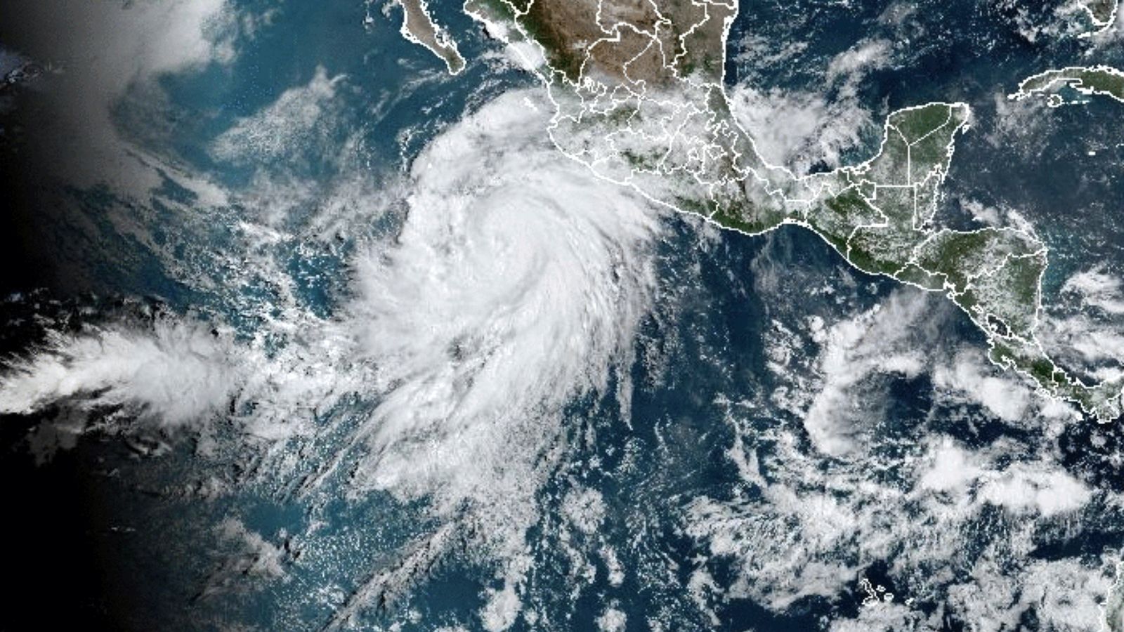
Hurricane Hilary has rapidly intensified, transforming from a tropical storm to a formidable Category 4 hurricane in just 24 hours. Presently located approximately 325 miles south of Cabo San Lucas, Mexico, Hilary boasts sustained winds of 130 mph accompanied by even more potent gusts, as reported by the National Hurricane Center.

The speed of this intensification process is noteworthy and indicative of the dynamic nature of tropical cyclones. Hilary’s strength is expected to persist as it draws closer to Mexico’s Baja California peninsula.
Consequently, hurricane and tropical storm warnings and watches have been issued for areas including Baja California and extending as far north as Point Mugu in Ventura County, California. These alerts encompass not only regions in Mexico but also parts of Southern California, including the Los Angeles area.
This development highlights the importance of timely and accurate weather forecasting in alerting communities and authorities to the potential threats posed by severe weather events. The ability to monitor and predict the behavior of hurricanes and their intensification processes is vital for ensuring preparedness, timely responses, and safeguarding lives and property in the affected areas.
As Hurricane Hilary continues its path northward, uncertainties persist regarding the potential impact of its strongest winds on the United States. The storm’s trajectory over the next few days remains subject to variation, and even slight deviations in its path can lead to significant shifts in the forecast for the most intense rainfall and wind.
A notable aspect of this situation is the hurricane’s unexpectedly rapid movement. As a result, both Mexico and California are poised to experience the storm’s effects earlier than initially projected. According to the latest projections, the hurricane’s core is predicted to approach the central part of Baja California on Saturday night, subsequently making its way inland over southern California by Sunday night.
This shifting timeline and the unpredictability of the hurricane’s path underscore the importance of continuous monitoring and updated forecasts. Timely and accurate information enables communities, authorities, and individuals to adapt their preparations and responses as needed. The dynamic nature of weather events like hurricanes emphasizes the need for flexibility and readiness in the face of evolving circumstances.
The National Hurricane Center (NHC) has indicated that the impacts of Hurricane Hilary will extend beyond the storm’s center, with strong winds and heavy rains anticipated to affect areas well before the hurricane’s center arrives.
While the most likely scenario involves Hilary making landfall in Mexico and crossing into California, there’s also the possibility that the hurricane could make landfall in California as a tropical storm. If this were to occur, it would mark the first such tropical storm landfall in California in almost 84 years, based on data from the National Oceanic and Atmospheric Administration (NOAA).
The unprecedented nature of the situation is underscored by the issuance of the first-ever tropical storm watch for parts of Southern California. Initially issued on Friday morning, the watch extended from the California/Mexico border through Los Angeles County. Later, in a Friday night update, the watch was elevated to a warning.
The increasing likelihood of significant wind impacts, especially in areas with mountainous terrain, has prompted the NHC to emphasize the potential for severe conditions in northern portions of the Baja California Peninsula and the Southwestern United States.
This heightened risk highlights the need for residents, local authorities, and emergency responders to remain vigilant and prepared for the potential impacts of this powerful hurricane, including strong winds, heavy rains, and other associated hazards.